
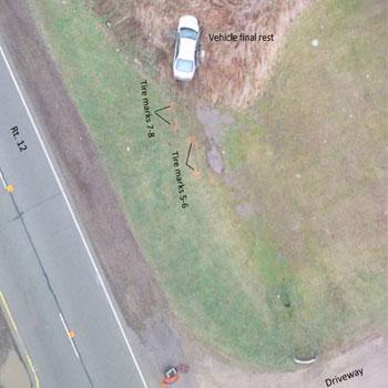
Single vehicle 10-50, Rt. 12 & Case Rd., Wauconda, IL - November 26, 2015
Case Study November 26, 2015
Before relying solely on UAV captured data to reconstruct an accident scene it is important to confirm that the information gathered will be sufficiently complete and of high enough quality to support any subsequent analysis. Using staged accident scenes we had previously evaluated a variety of techniques to survey the scene. These earlier test scenes allowed us to establish reliable strategies for the most effective flight patterns, altitudes, camera angles, flight speed, photograph overlap and more. We had already generally confirmed our ability to take accurate measurements from our models by comparing to distance measure on the ground using tape and by comparing longer distances with Google Earth. However, we still wanted to conduct a parallel investigation at an actual 10-50 callout so that we would be able to compare actual working results from the field.
Scene Characteristics
- Accident Description: 10-50 single vehicle
- Location: Rt. 12 & Case Rd., Wauconda, IL
- Temperature: 53oF; Overcast/Light Rain, Visibility 5-10 miles. Wind 15.0 mph southerly, Gusting 20 mph.
- Responding: Lake County's Major Crash Assistance Team (MCAT), Lake County Sheriff, Wauconda PD
- Extent of Scene: 1,000’ x 250’ scene (~5+ acres)
Comparison of Results
| Factor | Total Station | UAV |
|---|---|---|
| Time to Capture Scene | 4 hours | 25 minutes |
| Number of Points Captured | ~350 | ~35,000,000 |
| Time to Build Model and Diagrams | > 4 hours | 1 hour 30 minutes |
| Accuracy | Sub-centimeter | Sub-centimeter |
Model Tour
This video provides a brief narrated tour of one of the models costructed from this investigation.
Lessons Learned
- It will be possible to further improve the UAV data capture process when a Total Station is not being used in parallel. This is because the team working with the Total Station may add evidence markers as they worth through capturing the entire scene. In contrast, the UAV would benefit from having all evidence marked before beginning its flight.
- To make direct comparisons between Total Station and UAV results requires a common frame of reference i.e. using the same origin and orientation for measurements. This is not straightforward and requires some understanding of map projections and, depending on the tools used, potentially some matrix multiplication.
- Identifying an origin can be simplified if a clearly visible marker is placed on the ground at the origin i.e. directly beneath the Total Station
- The visual quality of the 3D Models can be improved when the aerial photography is combined with terrestrial photograpy of the vehicles.
- The flat and/or reflective surfaces of a vehicle cause some problems in post-processing the photographs. The software used matches photos based on a feature detection algorithm that does not work well on these types of surfaces. Glasss and water in the scene can cause additional reflectiosn that make model reconstruction more challenging.
Limitations
The UAV does not eliminate the need for:
- Detailed vehicle photos
- Evidence photos where “coin size” object detail recognition is required
- Evidence inspections (e.g., tire condition)
- Narrative
Do you have a case study you would like to share with the community? We would love to hear from you! Drop us a note from our contact page.